


Timici or Kalâa is an important archaeological site, bearing witness to the passage of Punic, Roman, and later Muslim civilizations, located near the village of Ain Metboul in the Dahra region of Algeria.
Toponymy
Timici is a Latinization of the Punic word tmky (𐤕𐤌𐤊𐤉). In the Middle Ages, the city took on its final name, Kalâa, a diminutive of Kalâat Maghila Deloul, meaning “castle of the Maghila Deloul,” named after its rebuilder Deloul Ibn Hammad, the prince of the Maghila under the rule of the Ifrenides. Ibn Khaldoun provides another name for the city, Igri, which today refers to the agricultural plain dominated by this city.
History
Punic Era
Timici was initially a Punic city that minted its own bronze coins with Punic inscriptions. Numerous sculptures of Phoenician character have been discovered there. The coin typology was inspired by the local religion and economy, with the city’s main agricultural resources being grains and grapes. The male deity engraved on the coins remains unidentified; J. Mozard hesitated between Baal or Eshmun.
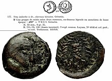
Coin of Ebusus with the seal of the Timici workshop
Roman Era
Under the Romans, Timici became a native city (civitas) in the province of Mauretania Caesariensis. Pliny mentions it in the 1st century among the important inland cities. According to Paul Pallary, the difficult access to the citadel and the lack of arable land make Kalâa a military city. This hypothesis is confirmed by the fact that it dominated the entire region and monitored both the fertile Gri plain and the Kouhlal valley. Its port, Arsenaria, was reserved for trade, later becoming a fortress to contain the region’s belligerents. Christianity appeared in the 3rd century, and the city was the seat of a bishopric, Episcopus Timicitianus, mentioned in the list of bishops gathered by Huneric, the Vandal king, in Carthage in 484.
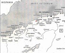
Location of Timici in Mauretania Caesariensis
Middle Ages
In the 10th century, the region came under the rule of the Berbers of Maghila, and the city was rebuilt by their emir Deloul Ibn Hammad, named in his honor Kalâat Maghila Deloul, “castle of the Maghila Deloul,” according to Al-Bakri. Thanks to the Irish orientalist Mac Guckin de Slane, the investigator of Al-Bakri’s “Book of Routes and Kingdoms,” the location of this city was determined to be two farsangs north of Mazouna and five farsangs from the sea. Ain Kordi, mentioned by the latter, is still in progress and is located near the village of Ain Metboul in Sidi M’hamed Ben Ali. In the 14th century, Ibn Khaldoun mentioned this city under another name, Igri, which fell into ruins, and the rich neighboring plain of Gri seems to have derived its name from it.
It was from the port of this city that the founder of the Umayyad dynasty of Cordoba, Abd al-Rahman I, departed in 755, to land in Almuñécar (al-Munakkab) in Andalusia. This port, located west of Ténès, is none other than Marsa Maghila, the former Arsenaria. In 1015, Hammad ibn Bologhine, the founder of the Hammadid dynasty, was defeated by his nephew Badis ben Mansur and took refuge in this castle (Kalâat Maghila). He then marched to the city of Dekma, plundered it, and transported provisions back to Kalâat Maghila, where he fortified himself under Badis’s siege until Badis’s sudden death in 1016.
Site and Monuments
The city is about one kilometer long and 200 to 300 meters wide, situated on a narrow ridge, adorned with two walls to the east and one to the west. On the north and south sides, paths were arranged along the flanks of the ridge, with a watchtower carved into the rock near each path. Numerous cisterns have been discovered, dug into the rock. A Christian chapel with columns is located about 80 meters from the southwest gate. To the east of the city, steles carved into the rock, adorned with crescents and sometimes preceded by cups, have been observed; remains of a vault carved into the rock: there was probably a cemetery there. The western part of the el-Kalaa plateau is devoid of any construction remains and occupied by a vast Punic necropolis of 300 to 400 tombs with pits and vaults carved into the rock.
Several ancient roads lead to Arsenaria, another to the city of Fundum Nomine Mazucanum across the Gri plain, and then to Castelum Tingitanum, and a third to the northeast via the ridges.
Timici or Kalâa is an important archaeological site, bearing witness to the passage of Punic, Roman, and later Muslim civilizations, located near the village of Ain Metboul in the Dahra region of Algeria.
Toponymy
Timici is a Latinization of the Punic word tmky (𐤕𐤌𐤊𐤉). In the Middle Ages, the city took on its final name, Kalâa, a diminutive of Kalâat Maghila Deloul, meaning “castle of the Maghila Deloul,” named after its rebuilder Deloul Ibn Hammad, the prince of the Maghila under the rule of the Ifrenides. Ibn Khaldoun provides another name for the city, Igri, which today refers to the agricultural plain dominated by this city.
History
Punic Era
Timici was initially a Punic city that minted its own bronze coins with Punic inscriptions. Numerous sculptures of Phoenician character have been discovered there. The coin typology was inspired by the local religion and economy, with the city’s main agricultural resources being grains and grapes. The male deity engraved on the coins remains unidentified; J. Mozard hesitated between Baal or Eshmun.
Coin of Ebusus with the seal of the Timici workshop
Roman Era
Under the Romans, Timici became a native city (civitas) in the province of Mauretania Caesariensis. Pliny mentions it in the 1st century among the important inland cities. According to Paul Pallary, the difficult access to the citadel and the lack of arable land make Kalâa a military city. This hypothesis is confirmed by the fact that it dominated the entire region and monitored both the fertile Gri plain and the Kouhlal valley. Its port, Arsenaria, was reserved for trade, later becoming a fortress to contain the region’s belligerents. Christianity appeared in the 3rd century, and the city was the seat of a bishopric, Episcopus Timicitianus, mentioned in the list of bishops gathered by Huneric, the Vandal king, in Carthage in 484.
Location of Timici in Mauretania Caesariensis
Middle Ages
In the 10th century, the region came under the rule of the Berbers of Maghila, and the city was rebuilt by their emir Deloul Ibn Hammad, named in his honor Kalâat Maghila Deloul, “castle of the Maghila Deloul,” according to Al-Bakri. Thanks to the Irish orientalist Mac Guckin de Slane, the investigator of Al-Bakri’s “Book of Routes and Kingdoms,” the location of this city was determined to be two farsangs north of Mazouna and five farsangs from the sea. Ain Kordi, mentioned by the latter, is still in progress and is located near the village of Ain Metboul in Sidi M’hamed Ben Ali. In the 14th century, Ibn Khaldoun mentioned this city under another name, Igri, which fell into ruins, and the rich neighboring plain of Gri seems to have derived its name from it.
It was from the port of this city that the founder of the Umayyad dynasty of Cordoba, Abd al-Rahman I, departed in 755, to land in Almuñécar (al-Munakkab) in Andalusia. This port, located west of Ténès, is none other than Marsa Maghila, the former Arsenaria. In 1015, Hammad ibn Bologhine, the founder of the Hammadid dynasty, was defeated by his nephew Badis ben Mansur and took refuge in this castle (Kalâat Maghila). He then marched to the city of Dekma, plundered it, and transported provisions back to Kalâat Maghila, where he fortified himself under Badis’s siege until Badis’s sudden death in 1016.
Site and Monuments
The city is about one kilometer long and 200 to 300 meters wide, situated on a narrow ridge, adorned with two walls to the east and one to the west. On the north and south sides, paths were arranged along the flanks of the ridge, with a watchtower carved into the rock near each path. Numerous cisterns have been discovered, dug into the rock. A Christian chapel with columns is located about 80 meters from the southwest gate. To the east of the city, steles carved into the rock, adorned with crescents and sometimes preceded by cups, have been observed; remains of a vault carved into the rock: there was probably a cemetery there. The western part of the el-Kalaa plateau is devoid of any construction remains and occupied by a vast Punic necropolis of 300 to 400 tombs with pits and vaults carved into the rock.
Several ancient roads lead to Arsenaria, another to the city of Fundum Nomine Mazucanum across the Gri plain, and then to Castelum Tingitanum, and a third to the northeast via the ridges.


