


Sedrata (in Berber: Isedraten) is an ancient Berber Ibadi city, located southeast of present-day Ouargla, in the Algerian Sahara.
The city experienced significant growth after the destruction of Tahert and the settlement of Ibadi refugees. It suffered two destructions (the last in the 13th century), forcing the inhabitants to flee again, this time to the Mzab.
The sand-covered ruins of Sedrata were rediscovered towards the end of the 19th century and contain sumptuous stucco decorations.
Toponymy
The toponym Sedrata refers to a Berber tribe from the Lawâta, widely dispersed across the Maghreb region. In medieval texts, the area of the ruins is included in a more general toponym, “Warjlân,” which seems to designate both the entire Ouargla basin and a habitat area that served as a central pole of this space.
It is sometimes nicknamed the “Atlantis of the desert” or the “Pompeii of the south.”
History

Sculpted niche from Sedrata exhibited at the National Museum of Antiquities and Islamic Arts in Algiers.
The history of the city of Sedrata is difficult to trace, as most texts referring to it use the general name of Ouargla. Contrary to popular belief, the city was not founded by the last Rustamid imam. The region’s adherence to Ibadism dates back to the 8th century, during the reign of the first Rustamid imam. Its connections with Tahert enhance its significance, making it an important stop on the trade routes leading to Sudan.
In 909, Tahert was destroyed by the Berber mountain tribes of Kutama, allied with the Fatimid dai Abu Abd Allah al-Shi’i. The city was destroyed, and its inhabitants were massacred or exiled. The refugees fled to the desert and settled in Sedrata.
Only in the first half of the 11th century did they gradually settle in the Mzab valley and build the five cities of the Mozabite pentapolis. The city was first destroyed by the Hammadid army around 1075, which fought against the Zenata. The oasis was attached to the Hammadid domain while retaining significant autonomy.
Around 1229, Sedrata was devastated by the Beni Ghania. According to an Arabic manuscript, the city was destroyed in 1274 by a troop leader of unknown political origin, referred to as “Qaïd El-Mançoûr El-Machriq.” This marked the end of the prosperity experienced in the 10th and 11th centuries. Present-day Ouargla then became the main center of the region.
The presence of significant aquifer resources explains why this oasis was once the largest palm grove in Algeria, and wheat cultivation was practiced there in the 12th century. As a fundamental node of trans-Saharan trade, the region saw the transit of gold until the 13th century.
Archaeology

Archaeological site of Sedrata.
The medieval archaeological site of Sedrata is located 14 km south of the city of Ouargla, in the northern Algerian Sahara. It is now almost covered by sands, stretching over more than two kilometers in length and six hundred meters in width, in a basin bordered by the Gours mountains.
The ruins house many stucco decorations, dated from the 10th to the 12th centuries. The decorations, real wall tapestries, were organized into panels with various motifs: rosettes, palm leaves, geometric patterns, and inscriptions. They evoke the motifs used in textiles, embroideries, but also some Christian decorations from Tebessa. It is here that the lobed arch and the horseshoe arch first appeared in the Maghreb. Some stucco panels are preserved at the Bardo Museum in Algiers, the Saharan Museum of Ouargla, the National Museum of Antiquities and Islamic Arts, and in Paris.
The ruins extend the art and architecture of the Rustamids. A mosque covered with juxtaposed oval domes and several residential complexes have been discovered. The art of Sedrata is characterized by its simple plaster decoration or Kufic inscriptions. The city seems to be a point of convergence of several influences from the East and the West. The absence of a topographic survey makes its understanding quite difficult.
The city was rediscovered in 1868. Numerous excavations have been carried out since the late 19th century, with new archaeological discoveries made in the 1950s, following the excavations of Swiss archaeologist Marguerite van Berchem. In the 1990s, archaeological excavations were resumed but were suspended in 2006 after the death of Ali Hamlaoui, whose doctoral thesis, defended at the Sorbonne, dealt with the city of Sedrata.
It comprises at least three settlement areas, connected by a dense network of communication, to which peripheral bordjs are added. The main core, to the south, is enclosed by a polygonal wall flanked by protruding towers and houses the great mosque. To the north, on a height, another complex surrounded by a wall and whose center contains a building profusely decorated with sculpted stucco, nicknamed the “palace with thirty-four rooms” by its excavators.
The third group includes a large rectangular enclosure, with an entrance flanked by a large tower. The rooms excavated around the central courtyard had abundant stucco decorations. At the foot of these agglomerations stretched mixed-crop palm groves. There is also the cemetery.
 Photo by Georges Marçais. | 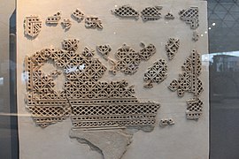 Department of Islamic Art – Louvre Museum. |
The architectural analysis of this city sheds light on the adaptation of a trans-Saharan society to desert constraints. The architecture of the city and the houses provides new knowledge on the so-called desert architecture. The integration of oasis areas and their palm groves was based on water management and the adaptation of cities to the fragile environment of the desert. A garden of palm groves protected by a stone wall has been unearthed and restored.
Sedrata (in Berber: Isedraten) is an ancient Berber Ibadi city, located southeast of present-day Ouargla, in the Algerian Sahara.
The city experienced significant growth after the destruction of Tahert and the settlement of Ibadi refugees. It suffered two destructions (the last in the 13th century), forcing the inhabitants to flee again, this time to the Mzab.
The sand-covered ruins of Sedrata were rediscovered towards the end of the 19th century and contain sumptuous stucco decorations.
Toponymy
The toponym Sedrata refers to a Berber tribe from the Lawâta, widely dispersed across the Maghreb region. In medieval texts, the area of the ruins is included in a more general toponym, “Warjlân,” which seems to designate both the entire Ouargla basin and a habitat area that served as a central pole of this space.
It is sometimes nicknamed the “Atlantis of the desert” or the “Pompeii of the south.”
History
Sculpted niche from Sedrata exhibited at the National Museum of Antiquities and Islamic Arts in Algiers.
The history of the city of Sedrata is difficult to trace, as most texts referring to it use the general name of Ouargla. Contrary to popular belief, the city was not founded by the last Rustamid imam. The region’s adherence to Ibadism dates back to the 8th century, during the reign of the first Rustamid imam. Its connections with Tahert enhance its significance, making it an important stop on the trade routes leading to Sudan.
In 909, Tahert was destroyed by the Berber mountain tribes of Kutama, allied with the Fatimid dai Abu Abd Allah al-Shi’i. The city was destroyed, and its inhabitants were massacred or exiled. The refugees fled to the desert and settled in Sedrata.
Only in the first half of the 11th century did they gradually settle in the Mzab valley and build the five cities of the Mozabite pentapolis. The city was first destroyed by the Hammadid army around 1075, which fought against the Zenata. The oasis was attached to the Hammadid domain while retaining significant autonomy.
Around 1229, Sedrata was devastated by the Beni Ghania. According to an Arabic manuscript, the city was destroyed in 1274 by a troop leader of unknown political origin, referred to as “Qaïd El-Mançoûr El-Machriq.” This marked the end of the prosperity experienced in the 10th and 11th centuries. Present-day Ouargla then became the main center of the region.
The presence of significant aquifer resources explains why this oasis was once the largest palm grove in Algeria, and wheat cultivation was practiced there in the 12th century. As a fundamental node of trans-Saharan trade, the region saw the transit of gold until the 13th century.
Archaeology
Archaeological site of Sedrata.
The medieval archaeological site of Sedrata is located 14 km south of the city of Ouargla, in the northern Algerian Sahara. It is now almost covered by sands, stretching over more than two kilometers in length and six hundred meters in width, in a basin bordered by the Gours mountains.
The ruins house many stucco decorations, dated from the 10th to the 12th centuries. The decorations, real wall tapestries, were organized into panels with various motifs: rosettes, palm leaves, geometric patterns, and inscriptions. They evoke the motifs used in textiles, embroideries, but also some Christian decorations from Tebessa. It is here that the lobed arch and the horseshoe arch first appeared in the Maghreb. Some stucco panels are preserved at the Bardo Museum in Algiers, the Saharan Museum of Ouargla, the National Museum of Antiquities and Islamic Arts, and in Paris.
The ruins extend the art and architecture of the Rustamids. A mosque covered with juxtaposed oval domes and several residential complexes have been discovered. The art of Sedrata is characterized by its simple plaster decoration or Kufic inscriptions. The city seems to be a point of convergence of several influences from the East and the West. The absence of a topographic survey makes its understanding quite difficult.
The city was rediscovered in 1868. Numerous excavations have been carried out since the late 19th century, with new archaeological discoveries made in the 1950s, following the excavations of Swiss archaeologist Marguerite van Berchem. In the 1990s, archaeological excavations were resumed but were suspended in 2006 after the death of Ali Hamlaoui, whose doctoral thesis, defended at the Sorbonne, dealt with the city of Sedrata.
It comprises at least three settlement areas, connected by a dense network of communication, to which peripheral bordjs are added. The main core, to the south, is enclosed by a polygonal wall flanked by protruding towers and houses the great mosque. To the north, on a height, another complex surrounded by a wall and whose center contains a building profusely decorated with sculpted stucco, nicknamed the “palace with thirty-four rooms” by its excavators.
The third group includes a large rectangular enclosure, with an entrance flanked by a large tower. The rooms excavated around the central courtyard had abundant stucco decorations. At the foot of these agglomerations stretched mixed-crop palm groves. There is also the cemetery.
| Photo by Georges Marçais. | Department of Islamic Art – Louvre Museum. |
The architectural analysis of this city sheds light on the adaptation of a trans-Saharan society to desert constraints. The architecture of the city and the houses provides new knowledge on the so-called desert architecture. The integration of oasis areas and their palm groves was based on water management and the adaptation of cities to the fragile environment of the desert. A garden of palm groves protected by a stone wall has been unearthed and restored.


